After our failed attempts at the summits of Mt. Agassiz and Bear Creek Spire, Ryan and I logically decided to aim even higher; a tougher climb that would take us above 14,000 feet and to the summit of Mt. Russell. Regarded as one of the finest 3rd class climbs in the Sierra, I’ve had my eye on this classic for a number of years. The route follows a striking line up a knife-edge arête with mind-boggling exposure, eventually leading to the twin summits of Mt. Russell (14,088 feet).

I’m not very enthusiastic at all about exposed scrambling, but I’m slowly getting more comfortable with it. I figured that this trip would be the litmus test to see if we’ve got the cajones to attempt all the California 14’ers (many of which require 3rd or 4th class climbing to reach the top). Even though I’ve done a lot of scrambling on this sort of terrain, it’s never been as sustained or committing as this. At the local crag, this sort of thing feels relatively comfortable and safe. It’s different when you’re out in the wilderness and on your own. I discovered that long stretches of such exposed climbing is mentally exhausting.

It could be argued that the crux of the route is the difficulty involved in securing a permit. The approach follows the North Fork of Lone Pine Creek (same as the Whitney Mountaineer’s Route) and this is not an easy permit to obtain, since most are reserved months in advance through a lottery. Thankfully, the nice folks at the Forest Service have posted the number of unused permits during past years, and we used this information to pick a weekend that would give us a legitimate shot. We drove to Lone Pine on early Saturday morning, hoping to get a permit for a Sunday entry. We did even better than that, and got a permit for immediate entry. So, after a quick lunch, we were headed up the Whitney Trail.

The trail up the North Fork was really easy to follow. I was expecting a lightly-used climber’s trail, but we could have followed this path through the forest by moonlight. After an hour of steep hiking, the canyon began to narrow and we were funneled into a chute with vertical walls on either side. Aha, we had reached the first route-finding crux of the approach: the Ebersbacher Ledges.

It is possible to thrash one’s way up through the thick alder to reach Lower Boy Scout Lake, but I’ve heard that it takes all day. And why do that, when there exists such a convenient, and somewhat alarming, short-cut to the top? The E-Ledges required a careful step or two, but weren’t as intimidating as I expected. We scrambled up blocky 3rd class to a lone tree, and then traversed across the granite slabs until we were able to reverse direction and head west onto safer terrain. It was fairly easy-going, but any snow or ice would have made the traverse extremely sketchy.

We quickly reached Lower Boy Scout Lake, and then continued up the now-faint climber’s trail towards Upper Boy Scout Lake. This is where we lost the trail, and we headed up a large talus field. Total time from the portal: one hour to reach the E-Ledges, another hour to reach the lower lake, and almost 90 minutes to reach the upper lake. Nearly 4,000 feet of elevation gained over a distance of ~5 miles. I was starting to feel a mild headache from the altitude, and was looking forward to a rest.


We reached Upper Boy Scout Lake (11,339 feet) and set up camp. The summits of Whitney and Russell were only a mile away, but remained hidden behind an imposing ridge. I spent the rest of the evening drinking lots of water and fueling up on Swedish Fish and M&M’s. I’ve completely abandoned freeze-dried backpacking food in favor of candy. Seriously.
Based on other’s trip reports, I figured that the climb would take us about 8 hours (barring any gross route-finding errors). Ryan and I decided to leave camp by 7:30 the next morning, and I set my alarm. Neither of us slept well at all; a combination of the altitude and our pre-climb jitters. I ate so many Swedish Fish that my jaw felt sore.
The next morning, we started up the sand and scree towards Russell-Carillon Pass. The route was less-than-obvious, but we knew the general direction and just followed the path of least resistance. We were 1/4 mile behind another party of two that had left earlier. Hiking up the soft sand was tough work.

In retrospect, we didn’t take the most direct route. The pass was hidden behind small pinnacles and outcrops and we wound our way up scree and talus in zig-zag fashion. Eventually, the slope became less steep and we were treated to a fantastic view of the imposing peaks to the west. The East Face of Mt. Whitney and the full length of Russell’s East Ridge loomed ahead. It took us 2-1/2 hours to reach Russell-Carillon Pass, where we sat and rested for a while. I switched out my boots for stickier 5.10 Guides, and drank a full liter of water. More Swedish Fish.

At the top of the pass, we found a single tent pitched amongst some big blocks. The closest water source would be Tulainyo Lake (12,802 feet), at the base of a very steep cliff. Only crazy people sleep at the top of high passes, I thought to myself. We caught up to the other two climbers, a man and a woman, at the pass. We exchanged a few words of encouragement. I could tell that the man was French, based on his accent. And the woman was Asian, based on her face, and the fact that she had dropped a couple of food wrappers covered in Japanese writing (wrappers that I stooped over to pick up, despite the fact that stooping over to collect litter causes throbbing head pain and momentary nausea when one is climbing soft sand at 13,000 feet). But, I digress.
I became contemplative as I looked up at the razor-thin ridge, which we would soon be perched upon. Frankly, I didn’t see how this would go at 3rd class. I wanted a rope. And a parachute.

The other climbers started up the ridge, and we gave them plenty of time to put some distance between us. Rockfall is common on this sort of terrain, and I didn’t want to get bashed in the head by a piece of dislodged granite. We watched as they made quick progress up the base of the ridge and onto the thinner section above. I felt slightly more confident in what we were about to do. If litterbug can do it, so can I.

After several minutes of easy scrambling, the ridge began to narrow and we reached a tricky section that involved straddling a sharp fin of rock. Totally safe and secure, but it was like sitting on a sawhorse perched at the top of the Empire State Building. We continued to negotiate the easiest path upwards, which hugged the north side of the ridge for the most part. There was easy trail in places (it was evident that the route sees a lot of traffic), but there were sections where we were forced to scramble atop the very spine of the ridge, which was somewhat exhilarating.

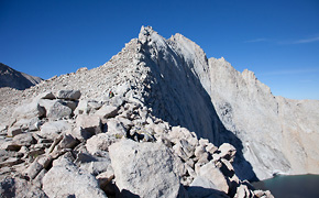
We eventually reached the first of two cruxes, where route-finding became critical to avoid harder terrain. In the picture above, you can see a climber (red backpack) as he negotiates his way along the north side of the ridge, on slabby 3rd class ledges. Those slabs below him drop away to vertical face, which is more evident in the photo below.

So, I can finally say that I’ve gotten a taste of “fantastic exposure” and I’m not sure that I like it. Without a rope or any protective gear, an accidental slip would send the unfortunate climber hurtling into oblivion. We moved very carefully over this terrain, maintaining three or four points of contact with the rock at all times. I tried my best to enjoy the climbing and the awesome vista, but there was a knot in my stomach the entire way. I reminded myself that as long as I moved carefully, I would be relatively safe. As safe as driving 75 mph on a highway, where a blown tire could easily result in a fatal crash. The only difference is that people drive fast on the highway all the time, so they get used to it and learn to ignore the danger. This would be the same.

In theory, at least. The reality that Ryan and I came to grips with, as we were getting higher onto the climb, is that extreme exposure is really scary, and being really scared has a way of messing with your head. We were close to 14,000 feet and pushing ourselves pretty hard physically, and the constant fear of “what if” began to take its toll on our motivation. The east summit was now in view, and I was close to the end of a final tricky section. Ryan was about 20 feet behind, and I could tell that he was really uncomfortable. He was satisfied with how far he’d come, and after talking it over, decided he would rather head back to the pass. I couldn’t decide what to do; I was pretty scared myself, but I knew that we had already passed the hardest climbing and the summit was only 15 minutes away. I waffled back and forth and finally decided that I would run up to the top and then meet him back at the pass. I knew I would regret it if I succumbed to my fears, which were only partially rational.

Twenty minutes later I was standing atop the east summit, with a truly fantastic view. In the picture above, you can see Upper Boy Scout Lake far below (right), where we had started our climb. With direct line of sight to the town of Lone Pine, I was able to send Jasmine a quick text to let her know that I was on top. It felt pretty good, but I was still pretty jittery. I wanted to get back down to the safety of the pass, and my head was starting to throb from the altitude. I took some pictures of Mt. Whitney, about a mile to the south. I could just barely make out some tiny figures on top.

I down climbed the blocky summit pinnacle and then retraced my route along the north side of the ridge. I made quicker progress now, being familiar with the route and having gained some confidence on this terrain. I could see Ryan up ahead, but he seemed to be lower on the ridge than I expected. It turns out that he had followed the wrong ledge system and had gotten off route after we split up. I traversed across the broken slabs until I was directly above him, and then I tried to help him find the easiest way back onto the route. He looked pretty gripped, and said that he had wandered onto some exposed 4th class, which was more than he bargained for. A few sketchy moves and he joined me on the ridge, and it was relatively smooth sailing back to the pass.


We made it back to Russell-Carillon Pass and rested for a short while, and then started the slippery slog back to Upper Boy Scout Lake. We basically plunge-stepped in soft sand for most of the way. My head was pounding; the dull ache had turned into a sharp pain behind my left eyeball. I desperately wanted to descend to lower altitude.

We made it back to camp and I immediately drank a liter of water, and then I crashed in the tent. Just under 8 hours round trip, as planned. My headache improved after taking a short nap, but I was still anxious to get to lower altitude, rather than spend another night above 11,000 feet. Ryan agreed, and we hiked back to Whitney Portal in about 2 hours, making good time.
This was a great climb, and I learned that my personal limit (risk vs. reward) is moderately sustained 3rd class on good rock. Had the difficulty been more sustained, or if we had encountered loose rock, I almost certainly would have bailed. Had we encountered inclement weather, or snow or ice, I would have bailed. Even though I can handle very short sections of 4th class without a rope, it’s all very situational. I have no interest in pushing that grade in the Sierra backcountry, where the weather can be unpredictable, the air is thin, and an accident would be catastrophic.
The High Sierra is loaded with great routes like this. Routes that I want to climb. It seems like most hardy folk climb these routes without a rope, relishing in the fantastic exposure and the purity of the movement, but Ryan and I realized that we cannot include ourselves in that crowd. That’s ok. I think we will continue to go to these high places, but we will bring a rope and some gear to minimize the risk of an accident, no matter how unlikely or in bad style. Or maybe we will stick to easier terrain, and leave the bona fide climbing to the crags closer to home. It’s all about having fun, after all.