I planned to do a backpack trip to the Dusy Basin last August, but the impending birth of my son forced me to abandon those plans. Scott was able to make it out and he came home with some nice photos. These would serve to whet my appetite for some images of my own.
It wasn’t hard at all to convince my mom to spend a few days in San Diego. Armed with backup, Jasmine gave me the go-ahead and I was giddy at the thought of an escape into the wilderness. It would be a short trip, but time has become a precious commodity these days.

In case you’re wondering, the answer is yes. I will be posting pictures of my little bug on these pages, every chance I get. I don’t have the time or energy to run another photo blog (not yet, at least).
My friend Ryan shares an interest in photography and climbing, and we had been talking about climbing the East Ridge of Mt. Russell. Early season snow put an end to that plan, so we decided on the Dusy Basin, as our fall back destination.
We drove to Horseshoe Meadows to acclimate on Thursday night. At 10,000 feet, it serves as an excellent camp before a trip into the high country. I brought along my old North Face Snowshoe, a sleeping bag rated to zero degrees. I shivered my ass off all night! That’s the last time I use that bag for anything other than slumber parties. I had no idea that synthetics lose so much loft, but then again, that bag is over 10 years old. Fortunately, I also brought my new REI Expedition, which is rated to a frigid -20 degrees. Overkill, I know, but I never got a chance to use it last winter, and I figured that a bivy near 14,000 feet would be a good initiation.
We drove to Bishop the next morning, ate at Schat’s Bakery, and collected our permit. The plan was to hike into the Dusy Basin, spend a night, and then climb Mt. Agassiz (13,891 feet) and bivy near the summit the second night. This would give us the opportunity to photograph the Palisade Crest and Palisade Glacier at sunrise, a longtime goal of mine. We could see some peaks from the trailhead, and though there was snow, we decided to leave our crampons and ice axes in the car. A decision that we would come to regret the following day, when we were halfway up the mountain and unprepared for the conditions.


The trail to the Dusy Basin passes through a charming valley and then climbs up and over Bishop Pass (11,972 feet). As we gained altitude, the small patches of snow continued to grow until we were hiking almost exclusively over a packed-down trail of the white stuff. After four miles, we reached the bottom of the pass and started our ascent.


After setting up camp and relaxing for a bit, Ryan and I headed off in different directions to scout the area for some nice photos. It was still well before sunset, but I wanted to investigate the area and find a nice location to shoot the sunrise. Sadly, as often is the case in the Sierra Nevada, I watched as the clouds slowly evaporated away, leaving behind nothing but clear blue sky. I did manage to make a few images before the clouds disappeared entirely, though.


It was getting chilly and I dashed back to camp to add some layers and grab my headlamp. There didn’t seem to be much hope that the Palisades or surrounding peaks would light up, so I prepared my dinner and relaxed for a while. Before it got completely dark, I moved my tripod to the edge of the little ledge we were camped on, and prepared the camera for a wide angle view of the entire Dusy Basin. The moon would be bright, and I figured it would be worth capturing an image illuminated by nothing but the soft lunar glow. Ryan prepared his camera for a star-trails shot using his intervalometer, which would turn out pretty neat.

The next morning, I shot some more photos and we loafed around camp until it warmed up a bit. Sometime after 10 am, we packed up our gear and made our way back to Bishop Pass. From there, we headed off trail and towards a very large boulder at the base of Mt. Agassiz. There, we ditched some unnecessary gear (bear canister, tent, etc.) and then eyed the various routes up the west side of the mountain.

Mt. Agassiz’s western flank is lined with alternating spiny ribs and wide, talus-filled gullies. We chose the widest and most benign-looking gully, and then started towards it’s base. We reached the large snowfield pictured above, and quickly discovered that it was easier to zig-zag our way up the snow rather than try and boulder hop. Ryan has some mountaineering experience, and he showed me the correct way to French step and front-point safely up the slope. He kicked steps and led the way, making it very easy to follow. We didn’t have our axes or crampons, but trekking poles helped us keep our balance. The angle of the slope felt intimidating at first, but I gained confidence as we moved higher on the mountain. Looking down at our zig-zagging steps was exhilarating to this first-time mountaineer. The footing felt secure, but I wondered what the consequences of a slip might be. It looked as if an uncontrolled slide down a 1/4 mile of snow would be the result. So, I tried my best not to slip.


After reaching the top of the snow slope, we began boulder hopping our way into the gully. Easier said than done – our packs were heavy and the snow was thigh-deep in places. We slowly made our way up the gully, which was starting to narrow and steepen. I was feeling committed now, and my heart was racing due to the exertion, the altitude, and the exposure. The middle of the gully was buried in deep snow and ice. We climbed along the steeper edge, where it felt safer to scramble up broken talus. I was paranoid about pulling a giant boulder onto myself, so I made an effort to climb in balance, testing any rocks that looked suspect.
An hour later, we had navigated our way to the upper part of the gully, where it turned north towards the summit plateau. We were getting close. Unfortunately, what started as 3rd class scrambling was starting to feel more like climbing. I checked my watch and it showed 13,000 feet – we were only 800 feet from the summit. Looking up, I could see that Ryan had come to a halt at an awkward, exposed area. He eventually pulled himself up and over some boulders and scrambled out of view. It was my turn, and I spent several minutes searching for a better option. I was starting to feel more and more uncomfortable. A big flake of rock jutted out in front of me, but it seemed awfully precarious. It must have weighed two hundred pounds (or more) and it was wedged in place by two meager points of contact with the surrounding boulders. It felt solid, but I couldn’t bring myself to place my entire bodyweight on this flake to pull myself up. If that flake blew, it would come crushing down on me and then we’d both tumble down the gully in a big, ugly mess.
I shouted up to Ryan and we began discussing our options. It wasn’t long ago that we were in a similar situation – on scary terrain and trying to decide whether to go up or down. I don’t remember my exact words, but they were something like, “This is horrifying…” We talked some more and he said something along the lines of, “Well, I don’t want to die.” I stemmed out as far as I felt comfortable, found a frighteningly small hold for my right hand, and then reached for a big sloper with my left. Relying on the friction between my hand and the rock, I pulled myself up and over this little crux and breathed a sigh of relief. That was an exposed climbing move with a 40 lb. pack on my back, and the thought of having to downclimb this terrain made me felt sick.
Lacking better equipment, we had reached the point where the risks outweighed the rewards. We considered dumping our packs and continuing on to scout the route, but the real concern was getting back down, not up. It’s almost always easier to go up than it is to descend. If the weather turned sour, there was no way we would be able to downclimb this terrain in a snowstorm. If we camped at the summit, the snow would likely ice over at night, making a morning retreat even more treacherous. Hanging out at the summit until the following afternoon didn’t seem like an option, since we had to be home the following night. It was a bittersweet decision, but we decided to turn around.
Later, Ryan mentioned that he was thinking about the newspaper headline during all this: Two Climbers Fall to their Deaths on Mt. Agassiz, Ice Axes and Crampons Left in Truck.


We plunge-stepped our way quickly down the chute and back to the snow slope. In retrospect, we should have stayed in the deep snow in the middle of the gully, rather than out on the exposed edge. This would have certainly offered safe passage to the top. Descending this slope in the morning would have been tricky, though, and there was no way of knowing how hard the snow would freeze at night. In any case, I felt like we learned something about snow travel and how to read the terrain, and I walked away from the experience feeling as if we accomplished something. And it was a heck of a lot of fun, too.
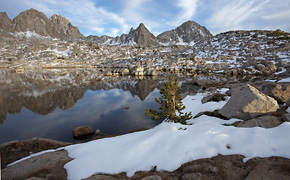
Instead of heading back down into the basin, we picked up our stashed gear and hiked up to a little knob above Bishop Pass. From our campsite, we had outstanding views of Giraud Peak and the Black Divide to the west, and Hurd Peak to the north. I wouldn’t get a chance to photograph the Palisade Crest from above, but some nice clouds appeared at sunset, and I came away with some keepers.


I’ll close this post with my favorite picture from the trip. On the hike out, as we approached the trailhead, we caught up to a small group of Asian hikers.
“Hey Ryan, check it out. Koreans.”
“How do you know they’re Korean??”
“Um, I can just tell. It’s the way they’re walking, see how they hold they’re hands behind their backs like that?”
They moved to the side of the trail and as we passed them by, I casually said kam-sam-nee-da which means thank you. They erupted in laughter and smiles. At the trailhead, there was an even bigger group and I offered to take their picture. From behind the camera, I said hana-dul-set (1-2-3) and then snapped the picture. More smiles and laughter. It was a ton of fun and I doubt they had any idea I had just used 90% of my Korean vocabulary in those two brief interactions. Actually, I wonder if any of them suspected I was half Korean, or just some random white guy who knows a few Korean words. We’ll never know.
