Bear Creek Spire (13,713 feet) is one of the classic climbs in the High Sierra, and it recently occurred to Ryan and I that we might be able to climb the mountain without a guide. This impressive granite peak awaits the eager climber at the terminus of the picturesque Little Lakes Valley, a hike I did with Scott in 2010. I was recovering from a back injury that summer, and I remember that the short hike to Gem Lakes felt strenuous. Flash forward two years, and I’d be doing the same approach through snow, with a 65 lb. pack full of climbing gear. Thank you, Motrin.

I’ve been climbing consistently over the past year, and after my experiences on Mt. Agassiz and Tahquitz, I felt prepared to tackle a slightly more difficult endeavor; the Northeast Ridge of Bear Creek Spire. My climbing partner Ryan was interested in giving it a shot, even though an early-season attempt in May meant that we would be dealing with snow and (possibly) ice. This would be my opportunity to learn how to self-arrest with an ice axe.
I downloaded the Supertopo guide and studied as many trip reports as I could find online. Three weeks out, and I was already feeling nervous. The climbing itself would be easy, but I wondered how I would handle the tremendous exposure. I was worried about the conditions, and I didn’t know if Ryan and I would solo the 4th class sections or simul-climb with a running belay. I knew that if we approached this like a traditional rock climb, our progress would be dangerously slow. The answers to these questions would become clear, I knew, as soon as we got onto the rock.
We departed San Diego on Friday evening and drove to Horseshoe Meadows (10,000 feet) to acclimate. After dodging a bunch of suicidal rabbits and rockfall on the road, we spent a peaceful night under the stars. I internalized most of my fears, but I was definitely having some doubts. Scared, even. I thought about Jasmine and Zane and the risks I was willing to take. I played scenarios out in my head. I knew that we would be getting on serious terrain where the cost of a mistake would be dear. I was excited.

Right at the start, a bad omen. We were making some final adjustments to our gear and were about to leave the trailhead, when I realized that I had left my iPhone at the pit toilet. I ran back to the shed and found a note, “I have your iPhone, I will call your home number when I get reception and will mail it to you. Angie.”
Ah, crap. I was really bummed. I usually feel lonely and homesick on trips like this, and I enjoy looking at pictures of my wife and kid to keep myself occupied during the down time. On this trip, in particular, I wanted to keep a close reminder of the things that are most important to me, in case I found myself in a dicey situation. As I have already written in previous reports, I tend to lean towards the dramatic. It’s just who I am. So I had lost my phone, and it felt as if my tenuous connection to the outside world had been severed.
We heaved our giant packs onto our backs and started up the trail. Bear Creek Spire loomed in the distance, gleaming white under snow. It sure looked steep from so far away, and it was funny to think that we would be climbing that thing.

It didn’t take long to reach Gem Lakes, where the trail comes to a dead end. This is where Scott and I camped in 2010, and he came away with a nice shot. The lakes were just beginning to thaw, and we encountered the first deep patches of snow. We started hiking up a steep drainage towards Dade Lake, our destination and intended campsite. With such heavy packs, it was difficult to keep from breaking through the soft snow, and at times we fell through to our waists. It was sheer cardiovascular ecstasy!


We finally reached Dade Lake (or so I thought) and we dumped our gear onto some rocks. Bear Creek Spire towered above. We were close enough that I could see some ski tracks down its flanks. Someone must have hiked up and skied its slopes earlier in the winter.


We relaxed a bit, and I punched some holes through the ice so that we could get water from the lake. I was feeling antsy, so I decided to scout the route some more. After 30 minutes of frustrating post-holing, I crested a knob and saw that we had stopped short of the real Dade Lake. Oops. I returned to camp, and we began discussing our options for the summit day. The Northeast Ridge, our intended climb, still held a substantial amount of snow along it’s face. As best as I could tell, we were facing some extended sections of snow-covered 4th class terrain. I was already uncomfortable with the prospect of such exposed climbing, and this was a deal-breaker. While I have no doubt that we could have made it up the route, I don’t think it would have been fun. Ryan agreed, and we decided to climb the Ulrichs Route, instead. This is the least technical route to the summit (and the route of first ascent, in 1923). Having lugged all our climbing gear out there, I suggested that we bring the rack and climb the 5th class headwall (only ~50 feet) for an exciting finish. We set our alarms for 6 am, and got some much needed rest.


By morning, the snow had re-frozen and felt nice and crunchy. We donned our day packs, strapped on our crampons, and started hiking towards the peak. It was much faster going, and I quickly began to appreciate this style of hiking. It felt very satisfying as the sharp teeth of my crampons bit into the hard snow with each step. We were traversing across a fairly steep slope, and I used my ice axe as a cane. A part of me felt as if I had finally become a mountaineer, and I smiled to myself.

We wound our way around Dade Lake and then even higher towards the base of the peak. Bear Creek Spire now rose directly above us, and oddly enough, it didn’t look quite as intimidating. As I examined the NE Ridge, I could see that it wasn’t nearly as steep as it first appeared, and there might even be ways to bypass much of the snow. Oh well, we were headed towards Cox Col, and the thought of climbing the ridge was still too scary.


Now we were hiking on a snow slope that received early morning sun, and the conditions were quickly deteriorating. Instead of biting into the hard crust, my boots were starting to sink and our progress slowed. I was sweating like a pig. I finally ditched my crampons and just left them lying on the middle of the snowfield (I recovered them on the descent). We started up Cox Col, and the slope steepened. I kicked steps into the snow and used my axe as a self-belay, trying my best to climb in balance. It was a lot of fun, but it was hard work.

Approximately 100 feet below the top of Cox Col, I decided to stash my ice axe on a small ledge and I switched to climbing the exposed rocks. This was mostly 3rd class terrain, with some benevolent 4th class moves that required care. A few minutes later, I was standing at the top of the ridge with a wonderful view to the west. I munched on M&M’s and relaxed while I watched Ryan make his way up the snow slope. He left his axe near mine, and then came to a stop at a little crux that involved a traverse around an exposed boulder. Ryan’s pack was bulkier than mine, and he had some trouble negotiating the move. He was carrying the rope, but I had an emergency tagline (a 30 meter Beal Rando). I set up a hasty anchor by wrapping one end of the rope around a giant block and then I tossed him the other end. Ryan tied off his pack so that he could shed the awkward pack and make the move. I watched as his water bottle slipped out of his pack, and then the map. Luckily, he was able to grab the bottle before it skidded away, but the map fell out of reach. A few things became obvious at this point:
- There is value in climbing light and fast, and with as small a pack as possible
- Messing around with one’s pack while in the midst of a climb should be avoided unless absolutely necessary
- Items like maps, water bottles, etc. had better be clipped off or secured inside zippered pockets
Losing a water bottle or map on this route wouldn’t have been a big deal, but I can certainly imagine a scenario where it would have ruined the day, or even been dangerous.
Ryan joined me at the top of the ridge shortly thereafter, and we rested our legs and lungs. At 13,000 feet, the air was feeling thin.
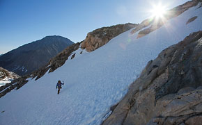
This is where I made a stupid route-finding error, that I can only attribute to the fact that I was nervous about the climb. I looked down at our route of descent, and it sure looked steep. I’m sure that a seasoned mountaineer would happily glissade down such a chute, but it looked like a slope that might usher me to an untimely demise. We still had altitude to gain, and I stared at the ridge ahead. I knew we had to move up and towards the right, but I didn’t realize that the summit was directly in front of us. Instead, I focused my attention on a triangular rock that looked like the summit block that I had seen in pictures. What frightened me was the 60 degree snow-covered slope that led to this block; I didn’t see how we could possibly traverse it safely. So I started heading up, and I aimed for a notch in the ridge, which I hoped would be snow free and enable us to traverse to the summit.

Looking at the photo above, it’s a fairly straightforward route to the summit. I’m not sure if it’s the angle or an optical illusion, but it wasn’t nearly so obvious at the time. It’s possible that I was just gripped and trying to think with my oxygen-starved brain. Who knows. The climbing here was pretty easy; boulder hopping down low that eventually turned into borderline 4th class climbing as we gained the ridgeline. I had my eyes set on the high rock features to the right, and we gained the ridge near the snow-covered saddle to it’s left. Talk about exposure! I made the final moves to the ridge and peered over the edge; it looked like a 1,000 foot vertical drop to the valley below. It was exhilarating, but I had absolutely no desire to climb on such exposed terrain. Bleh, maybe I’m not a mountaineer, after all.


Ryan joined me and we ate some snacks and took pictures from our lofty viewpoint. I guessed it would have taken us 30 minutes to climb to the base of the summit headwall, but I felt satisfied with the view and ready to retreat by that point. I told Ryan that I would continue higher if he desired, but that I was prepared to make our descent. I was just physically exhausted and psychologically unprepared to expose myself to further risks. I think he shared my feelings, and we made our way back down to the notch at the top of Cox Col. Downclimbing from the ridge required some care, but it passed without incident.
We still had ~200 feet of steep terrain to negotiate, and we decided to set up a rappel by slinging a huge block with some 1″ tubular webbing and one of Ryan’s rap rings. I made my way down carefully, picking up our map about halfway down.


We rappelled down half a rope length (100 feet) and stopped at a reasonably secure ledge, where Ryan re-flaked the rope. I knew we would be plunge-stepping the rest of the way, but I wanted to follow Ryan since the steepness of the slope still gave me pause. I watched as he took his first few steps; I was half expecting to see his feet slide out from under him and watch as his body went tumbling down the mountain. Instead, he sank deeply into the soft snow, which was very safe and secure. Whew.

I gained confidence as the slope mellowed some, and we began glissading the sections where it was possible. Using the pick of my axe as a brake, sliding down the slope was certainly faster (and easier) than plunge-stepping. I commented that I would have happily paid $100 for a snowboard, which I could have ridden most of the way back to camp.
We made it back to the campsite by 3:30 pm, and after some discussion, we decided to pack everything up and hike back to the car before dark. It was already a very long day, but having (nearly) accomplished our objective, we both felt like getting home as soon as possible. I wanted some real food, too. My legs were wobbly and my shoulders ached, but we made it back to the car just before sunset. I have no doubt that we will be back to summit this peak in the near future.
I should also add that I ran into Angie on the trail, and recovered my iPhone only one hour into the hike. A good omen, for next time.